Its March 25th and the Lasswells are off to California in search of sun, warm weather and adventure. Our first major trip of the year and we are driving to Bend to visit an old friend then down Highway 395 through eastern Oregon and California eventually ending up in the Saline Valley, part of Death Valley National Park. Along the way we plan on visiting hot springs and old ghost towns in the high Sierras . At least that's the plan.
We get a late start, and as usual don't end up leaving for Bend until after noon. Heavy traffic around Portland as well as snow and compact ice on the pass over Mt. Hood slow our progress so we don't get into Bend until after 8 PM. We hook up with Mike and his girlfriend and are off to the Deschutes Brewery for frosty cold barly pops, a perfect end to a day of driving. Mike was kind enough to let us camp in his driveway and Cayenne got to spend some quality time romping with his pooches.
After a light breakfast we topped off the fuel tank and headed East out of Bend on Hwy 20. We read about a place along Hwy 20 called Glass Buttes which is a 2000 foot high obsidian outcropping that sits above the desert where ancient peoples used to come to fashion arrow heads. We figured it should be fairly easy to find, after all Eastern Oregon is high desert so there are not a lot of trees, and 2000 foot outcropping of obsidian should be fairly obvious, not. We reached Hwy 395 without seeing any trace of the buttes or the small road that lead to them. We'll have to try again next time we pass through this area.

Hwy 395 though Oregon is a desolate two lane highway running through the high desert with miles of open land framed by snow covered mountains. The traffic was extremely light which made for very pleasant driving.

This part of Oregon is home to Pronghorns which neither Dana nor I had seen before. We almost gave ourselves whiplash when we saw the first one grazing along the side of the road. At the time we didn't know what we were looking at, all we knew is it wasn't a deer or elk. After we returned home I was able to identify it through the wonders of the Internet. There is a very interesting page on Wikipeadea about them http://en.wikipedia.org/wiki/Pronghorn. They were almost extinct at one time but they are now thriving in Oregon, as we saw some very large herds. Here is a little trivia for you, they are the fastest land animal in North American and can run 50-60 mph for extended period of time. We did see two of them chasing each other around a farmers field, I don't know if they were going 50 mph but they were really movin'.

Making good time through Oregon, by lunch we had almost reached the California border. We stopped at a senic spot along the shore of Goose Lake for lunch. Trafic was light and only a couple of cars pass in the hour we were there.
Shortly after crossing the boarder into California, we were traveling along the Pitt River when we spotted three derailed train cars on the opposite bank which had spilled their cargo. The cars appeared to have been there for sometime, I guess the track isn't used and instead of retrieving the cars they just decided to leave them. Whatever the reason, it made an odd sight and we debated for the next couple of minutes whether we should turn around and take some pictures. Since there are no pictures here it is obvious what we decided, but now as I am writing this I am wish we had stopped.
A few miles farther South we turned East onto Hwy 299 toward the small town of Cedarville. Once there we turned South to the even smaller town of Eagleville. Eagleville, we discovered, is the kind of place where everyone waves as you drive by. Even the drivers of passing pickup trucks (there were very few cars on the road) waved. I am not sure if this is because the people of Eagleville are exceedingly friendly in a Beaver Cleaver kind of way or the fact the front our van bears a strong resemblance to a U.S. Forest Service truck that followed us for a while the next day.

After turning around several time we located the Eagleville Hot Springs which is just off the highway South of town. It is a pleasant rock pool located right along the edge of the highway but down a 15' embankment. The air temperature was a little chilly 50 degrees because the elevation is just shy of 6000', but the water was a pleasant 101 degrees so we settled in for a nice afternoon soak.

We had a beautiful view of the valley from our pool.
No camping was allowed in the area around the hot spring, however we had spotted a sign for a Forest Service campground just up the road a couple of miles. Turning off the road we passed a couple of farms, crossed a cattle guard and at this point the road began to climb steeply and became much narrower. This was not a good sign since the main road was at nearly 6000 feet in elevation. It wasn't long before we saw snow beside the road and then in the road. Uh Oh! Half way through the next switchback the van started to slide sideways toward the inside of the curve. At this point I decide 4-wheel drive would be a good idea. Getting out to lock the front hubs I discovered the road was very soft from all of the water running off of the melting snow and as we drove our tires churned it into thick sticky mud. Our tires looked like giant reddish brown mud doughnuts. Even with 4-wheel drive we were only able to drive another couple of hundred feet before the snow covered the road for as far as we could see. Not wanting to test our winching skills we backed down to a spot where could turn around and headed down. It was almost dark, we were hungry and at this point any reasonably flat parking spot would do for the night. At the bottom of the road we located a flat area next to a diversion channel a farmer had dug for irrigation and set up camp. Never mind that pesky NO TRESPASSING sign.
Not wanting a confrontation over our choice of camping spots, we were up and on the road early the next morning. On the way back to Eagleville we spotted a farmer plowing his field. A truck was parked at the edge of the field closest to the road and a man was standing in the bed with a rifle pointed at the tractor. It looked like he using the tractor for target practice. In reality, we surmised there must be gophers or some other burrowing rodent that he was shooting as the tractor disturbed them.

That morning we also spotted a large flock of Blue Heron and a herd of what must have been 100+ prong horns and to many white tailed deer to count. Our buddy Taro would have had a huntergasm. We counted at least 7 bucks just in this picture and this is just a small part of the herd.
We passed through the towns of Likely, Sage Hen, Madeline, Moran, Termo, Ravendale, Susanville, Milford, Herlong Junction, Doyle, Constantina, Hallelujah Junction and Antelope before hitting the Nevada border. We stopped in Reno to fill up on cheap diesel and have lunch before crossing back into California.
After an unsuccessful attempt to locate Fales Hot Springs, which involved much turning around, head scratching and pondering the somewhat unclear directions in our guide book, we arrived at the turn off for Buckeye Hot Springs. There are two roads into Buckeye and being adventurous people we decided to drive in the shorter but rougher road and out the longer and mostly paved road.

The road was muddy, snowy, and very narrow in some sections. We were however rewarded with some spectacular views of the valley below.


After more turning around, head scratching and pondering the less than clear directions in the guide book we finally found Buckeye Hot Springs. Located at the base of a steep embankment Buckeye is formed from a spring running down the embankment and then cascades into stone pools at the edge of Buckeye creeks. There are several pools of varying temperatures and even though there were two other parties camped in the area we had the hot springs all to ourselves.

We found mostly flat parking spot along the creek a short distance from the hot spring and set up camp. That night while walking Cayenne I found a plaque explaining the clearing where we camped had been the sight of a large saw mill that prospered from around 1880 up until the late 1920's and supplied much of the lumber that built the ghost down of Bodie, which we would be visiting in a few day. Unfortunately, there were no traces of the old mill left.
The views of the mountains here are spectacular and this hot springs is one of the best we visited on the trip. If you are ever in the area you should stop and visit. The easier road is passable by normal passenger cars during the late spring and summer.

Saturday, Day 4, we slept in a little late, leisurely make coffee and yummy breakfast burritos, then went for another dip in the hot springs. We had made good time so far, we were more than three quarters of the way to Saline Valley, and there were several other hot springs close by so we were planning a relaxing day without much driving. Bridgeport which is a larger small town was nearby and we planed on stopping to fill our fuel and water tanks, as well as buying groceries. On the way into town we took a detour to see the Twin Lakes which was just a few miles up the road from the turn to Buckeye. Nestled in a steep mountain valley and surrounded by snowy peaks the lakes are really beautiful and were definitely worth the side trip. The last lake was still mostly frozen.
After finishing our chores in Bridgeport, we drove to Travertine Hot Springs which is only a few miles out of town. As the name suggests the hot springs are located along a ridge of travertine, which is formed when water from the springs flows through subsurface limestone leaching minerals out which then resolidify at the surface. The hot springs were crowded and the pools were murky and unattractive. We did meet a nice couple from Winthrop and spent time chatting with them as Cayenne played with their dog. In one of those small world moments it turns out they know Dan and Kristi Brookshire who we met in Baja last winter.
Our guide book listed another hot spring called Molly's Pool, which was supposed to be located close by. We asked some of the locals at Travertine but no one there had heard of it. Undeterred, we hiked around the area, scratched our heads and pondered the less than clear directions in the guidebook.
While scouting around we found a hole about 12 inches in diameter filled with hot bubling water. As we were peering into it we could see that it flared our as it went down which didn't make us feel very secure standing at its edge. We dropped in a few pebbles which drifted down until they disappeared from sight. It is deep! I wish we would have snapped a picture.

After 30 minute of hiking we located the pool on the side of a valley over a ridge from Travertine Hot Springs. Molly's pool is a real treasure, especially because it is not heavily used. It is a small pool that can hold two people with crystal clear water, about 102 degrees and no odor. It overlooks a small valley with a stream, framed by snow covered mountains. Needless to say we stopped for a soak.


That evening we returned to the access road for Buckeye Hot Springs. Just after leaving the paved road we crosses a creek in an open valley and found a small trail along the creek where we were able to set up camp. The wind came up and the temperature dropped into the 40's. It would get even colder with temperatures in the high 20's at night and strong winds. This prompted Dana to ask "Didn't we come down her to find warm weather and sun?" Well, at least it was still sunny.

The view of the creek from our campsite.

The next morning we were off to Bodie. Bodie is a ghost town high in the Sierra mountains. Established in 1859 Bodie thrived until the 1920's. The last mine closed because of WWII in 1942 and the town was abandonded. By this time most of the town was owned by one man who kept a caretaker on site to prevent vadalism, becaue of this most of the buildings still have their furnishings intact. The townsite was taken over by the California Parks System in 1961 and since then has been kept in a state of suspended decay.

Turning off the highway, our enthusiams to see Bodie was momentarily tempered as a locked gate blocked our way. As you can see by the picture we are parked behind the gate. On the left was a clearing where a semi-truck could have driven around the gate. Perplexed, we pulled up and read the small sign attached to the "Road Closed" sign. It stated, "the road was closed and if you drive the road you may be subject to citation and tow companies may not help you if you become stuck." We interpreted this to mean if you are dumb enough to get stuck and the park service has to come rescue you they will give you a ticket, so we drove around the gate. A white Subaru had pulled up behind us while we were reading the sign and they followed us up the road as well, atleast we had company.
A mile and a half short of the town site we reached another gate, with no way drive around, so we parked and put on all of our warm clothes for the hike in. The town is located at 9000 feet and the outside temp was 30 degrees with 15 to 20 mph winds. BRRRRR!

Dana all bundled up for the wak in.

Taking refuge infront of the morgue. There are still cofins inside, spooky!

This is one of my favorite pictures from Bodie.


Taking refuge from the wind inside on of the few open buildings.


This seusian looking builiding was the mill that cut firewood for the town.

The Mine
 The saloons. The picture is a little blury because it was taken through the window glass.
 One of the fancier houses.
 Checking the price of gas?
 The auto repair garage.
 The general store.

Why does the hike out always seem shorter than the hike in? Whatever the reason, we were thankful for this phenomenun because after walking around Bodie for an hour we were chilled to the bone. Back in our van we made hot chocolates and soup for lunch. We decided that our trip had gotten somewhat off course as our goal was to find sun and warm weather. To date we had gotten penty of sun but because of the elevation had not seen temperatures over 50 degrees. It was time to head to the desert. Saline Valley here we come!
Saline Valley Hot Springs was still about 5 hours drive on the highway plus another 3 hours of washboard desert roads so we decide to spend the night at Little Hot Creek. This hot spring was described as being down a rough 4 wheel drive road with ample primitive camping amongst the trees. Our king of place! This was also one of the most interesting hot springs we visited becasue the creek is 10-15 feet acroos and flows out of the hillside at approximaely 180 degrees. One of the oddest things is there are small fish that live in the hot water of the stream.

In the morning it was very cold (25 degrees) and the whole creeks was steaming which was very surreal. I tried to capture it in a picture but the wind was blowing the steam away so the picture doesn't do it justice.
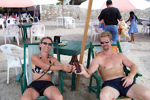
Upon arriving we found a group of moutain bikers and the white Subaru that was behind us on the road to Bodie. They had opted not to hike the mile and a half to the town. The soaking pool is quite large so we joined everyone in the tub. We had a nice chat shared a few beers and as it turned out the two women in the Subaru who had followed us earlier also new a couple of the mountain bikers from college. Weird coincidence.
Unfortunatly the soaking pool was only luke warm. The creek has a small rock dam which diverts water into the soaking tub though a series of pipes. Some of the pipes had become partially disconnected so the hot water was only trickling into the tub. Later I waded into the knee deep muck of the stream in a futile attempts to repair the leaking pipes. All I manage to accomplish was to destory the only pair of hiking sandles I brought. Dooooh!
The next morning after a windy and bitteryly cold night, well atleast out side of or nice warm Sportsmobile, we broke camp and explored several of the other nearby hot springs. Finding Sheppard Bath Hot Spring deserted and delicously warm the whole family, Cayenne to, took a much need bath before hitting the road to Saline Valley. We stopped at Bishop to buy fuel, groceries and fill our water tank. We also found a K-Mart where I was able to buy some more sandles. I have never been so happy to see a K-Mart in my life.
Before leaving Bishop we call the Death Valley National Park office to register our trip plan and get the required permits. When I gave our name to the park ranger he informed me that the Lasswell's were one of the first families to settle in Death Valley. Upon returning home I Googled "Lasswell Death Valley" and sure enough on page 4 of the Death Valley Visitors Guide it tells the story of how Andrew Lasswell was one of the first settlers in Death Valley in the 1870's. Trippy!!

10 miles South of Bishop we turned off Hwy 395 onto Death Valley Road which climbs steeply for 7 miles as it winds through dramatic rock canyons. As the road leveled out we turned onto Saline Valley Road and left the pavement behind. The next 40 miles would be on rough desert roads, they actually aren't that bad and your average SUV could easily make the trip. On the way in we passed an old school bus which had stopped to cool down after a steep section of road. We learned later it was the "Techno Bus." It was owned by some young Russians, had a dance floor built on the roof, and a loud stero system which boomed techno into the wee hours of the morning. We were really, really glad they weren't at the hot springs while we were there.


Only a short distance from leaving the pavement we passed through an old mining camp which had a few buildings and old equipment left.

As we dropped down to the valley floor, a verticle distance of about 4000 feet, the temperature constantly rose until it was a pleasant 75 degrees. After 3 hours we came to the turn to the hot springs where we cold see the palm trees surrounding the springs in the distance across the valley.

Nearing the hot springs we encountered a very intersting art installation.
Saline Valley Hot Springs is truly an oasis in the middle of the desert. There are two developed springs the lower of which is the most elaborate. Full grown palm trees surround the lower springs which has two large concrete soaking tubs. The upper tub, the sunrise pool, has a wide view of the sky and is perfect for early morning soaks, hence the name, and also for stargazing. The lower tub is surrounded by creosote bushed which have been trained to grow over it creating a beautiful and uniqe cover which provides shade during the hot days. The water for the lower tub flow out over a collection of very large crystals which were collected at a nearby site. The lower springs also has a shower and tub strictly for bathing, a large lawn area with a coi pond and there is even a cold pool for the really hot days. The most amaizing thing is that even though the hot springs are now part of Death Valley National Park it was built in the 60's by volunteers and is still maintianed soley by volunteers.

We set up camp on a small hill on a small hill overlooking the lower spring and as we were cooking diner a F-18 flew overhead at about 500 feet with the afterburners lit. If you haven't seen a jet make a low pass on afterburners at night it is a really, really, really impressive. The jet had huge plume of blue flame coming out of the back. The whole of Saline Valley is a military training area for low altitude flight and we were treated to our own personal air show every day.

We spent the first two days relaxing, soaking up the 90 degree heat and watching the wild burros wander through to drink from the cold pool. We met a ton of interesting eclectic peopel, Ingrid the weed fairy from Berlin, a couple from Oregon camping in an old Chevy van, the guy from New York who was traveling with his son in a vintage (80's) Sportsmobile.
On the third day the weather changed and a violent wind storm blew in churning the valley into a dusty mess. Fortunately for us the wind was blowing over us into the valley so most of the dust was well away from where we were camped. We were lucky we had NRRVANA whcih gave us somewhere to take refuge from the storm. Many of the campers were in tents and were either stuck in the their cars or tents the entire day. The next day the calm beautiful weather return, unfortunately this was aslo the day we had to head for home.


